Medicine Bow Rail-Trail
 Build it and they will come….
That was the dream of many involved with making the Medicine Bow Rail-Trail a reality. This trail is a non-motorized trail that has been converted from a portion of the abandoned Laramie, Hahns Peak and Pacific Railroad. Construction of the trail began in the summer of 2005 and it was just completed in August 2007.
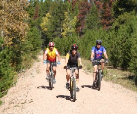
The Rail-Trail has a hard-packed gravel surface (like that found in a baseball outfield) averaging 10 feet wide.
It is suitable for mountain bikes or cycle-cross bikes (road bikes are not recommended).
Grades and curves are very gentle and suitable for users of varying abilities.
The trail is 21 miles from the Pelton Creek Trailhead in the south to the Dry Park Trailhead in the north.
The Pelton Creek, Woods Creek and Lake Owen Trailheads are open for use.
All three have accessible vault toilets and picnic tables. Lake Owen has a hand pump for water.
The outhouse at Lincoln Gulch was installed in summer 2008 – and it’s a donation from Cycle Wyoming to the trail users.
- Trail Segment Descriptions
- Pelton Creek to Vienna Trailheads (6 miles)
- Vienna to Woods Creek Trailheads (5 miles)
- Woods Creek to Lincoln Gulch (3 miles)
- Lincoln Gulch to Lake Owen (5 miles)
- Lake Owen to Dry Park (2 miles)
- Getting There
 Click on the trail segments for descriptions of each section.
Pelton Creek trailhead marks the southern end of the Rail-Trail.
Facilities include a restroom, picnic table and gravel parking area where a parking use fee is required.
The Vienna trailhead lacks any facilities but is well suited for horseback riders to load and unload their horses.
The path between these two trailheads is resurfaced with small gravel and it has rolling terrain. There’s a bit more of an uphill going from Pelton Ck to Vienna.
This segment offers great solitude and has probably the least traffic. Cows like the route, though, and they can creat a lot of divots on the trail if it’s wet.
The trail along this segment is resurfaced with small gravel. The Woods Creek trailhead includes a restroom, picnic table and gravel parking area that requires a parking use fee. The trail is resurfaced but needs more use to keep weeds from sprouting on the path. The trail passes through a small segment of the 2003 Gramm forest fire, making it interesting to see how the forest is coming back.
The trail crosses Highway 230 with easy-to-open gates on each side of the highway. Use caution when crossing the highway. The trail from Highway 230 north to Fox Park is unimproved and rough. A culvert washout was repaired in 2007 but resurfacing was not completed. It will be resurfaced eventually. While the route is rough, it is fine via mountain bicycle and is very scenic.
The Rail-Trail reroutes through Fox Park due to the lack of access for a short segment of the railbed. There’s a steep but very short drop from the railbed to the gravel road that curves through Fox Park. Follow Forest Road 512 for a short bit before taking the 90-degree turn onto Forest Road 517, heading north. Follow this road just past Fox Park and then turn north, back onto the Rail-Trail.
The Lincoln Gulch trailhead has a gravel parking area and a restroom donated by Cycle Wyoming.
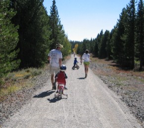
This segment of trail is the most bicycle-friendly of all the trail segments due to the more compacted surface. Parking at either end and doing an out-and-back is an excellent route for a family outing. The trail is resurfaced with small gravel and the terrain is flat to rolling.
The trailhead at Lake Owen includes a restroom, picnic tables, potable water supply and gravel parking area. A caboose is also on the site along with information reader boards about the railroad. An added treat is the handicap-accessible hiking trail that takes a mile-long path around Lake Owen. A campground and additional parking areas are on the southeast end of the lake and all sites require a day use parking permit.
The trail from Lake Owen to Dry Park is a bit soft, but has a small gravel surface. The terrain is flat to rolling.
The Dry Park trailhead lacks any development or facilities, but has a dirt parking area. There is no fee required to park at this site.
The nearest airport is in Laramie, a half hour drive from the trail on either U.S. Highway 130 or 230.
Denver International Airport is 150 miles away. Driving from Denver can be more economical than flying into Wyoming.
To start at the northern-most trailhead on Dry Creek Road, head west out of Laramie on U.S. Highway 130 and go 22 miles and then turn left onto State Highway 11/WY-11. Continue 11 miles to the small community of Albany. Continue on Forest Road through Albany (it becomes FR 500). After 2.2 miles, turn left (the turn is not well marked) onto Forest Road 513. Continue 2.5 miles and turn left on FR 517. Continue 1.5 miles. At intersection, go straight to get to Dry Park Trailhead in 0.6 miles or turn left to go to the Lake Owen Trailhead. The Dry Park trailhead is only a wide dirt area along the road; there are no facilities. Facilities at Lake Owen include a caboose and toilet.
Another option is to follow directions to Woods Creek Trailhead but continue past that trailhead for 1.1 mile FoxPark turn onto FR 512. Follow road through FoxPark and follow signs on FR 517. This route is longer to Dry Park and Lake Owen but currently is not as rough as the road out of Albany.
To start at the southern end at the Woods Creek or Pelton Creek trailheads, head out of Laramie on U.S. Highway 230. After 25 miles you’ll enter Medicine Bow National Forest. Continue on the highway another 6.5 miles to the Woods Creek trailhead, located on the south (left) side of the highway. If you prefer to start at the southernmost end point, continue another 7.5 miles down the highway to the Pelton Creek trailhead. Just after crossing the Wyoming-Colorado state line, turn north (right) on Forest Road 898. The trailhead is one mile down this gravel road.
A daily fee ($5) or season pass ($30) is required for parking at the five developed trailheads; parking at the Dry Creek Road trailhead is free.
Trail Information
The rail-trail is marked with mileage posts every mile, but the miles are the distances of the entire historical railway that started in Laramie. All trailheads have parking areas; there are restrooms at all but the Dry Creek Road and Vienna trailheads. Lake Owen is the only site with potable water.
In the snowy months, the ungroomed rail-trail attracts skiers and snowshoers. With an elevation ranging from 8,770 to 9,030 feet, the trail stays wintry well into the spring. Cyclists and horseback riders should wait until mid June to get on the trail, while runners and hikers willing to dodge the occasional snowdrift can get on sooner. Some of the best cycling is in the fall, but trail users should wear orange vests during hunting season—normally the month of October. Full-suspension and hybrid mountain bikes work well on this trail. Motorized vehicles are not permitted.
A Brief History
Occupying the corridor of an early 20th century rail line through quintessential western forest and mountain terrain, the Medicine Bow is Wyoming’s newest—and longest—rail-trail; the grand opening was held in late September 2007. Former District Ranger Clint Kyhl saw the project through from its start in 2001. “It began with a feasibility study conducted by a private contractor and funded by the Wyoming Department of Transportation,” Kyhl says. Once the study was finalized, U.S. Forest Service personnel stepped up to move the process forward, with Kyhl leading the charge
“There were two main reasons the Forest Service got involved,” he says. “First, the railroad bed structure was in good shape and we wanted to put it to public use. Second, the community support for the project was overwhelming, in both enthusiasm and dollars.” Working with the Laramie Bicycling Network, Cycle Wyoming, the Wyoming Department of Transportation, the City of Cheyenne Board of Public Utilities, and the Wyoming Institute for Disabilities, Kyhl’s team raised more than $1 million, which was used to resurface the rail-trail, repair culverts and clean up debris along the corridor. In addition, the money funded construction of five trailheads—all with parking lots and four with restrooms—and a mile-long circuit trail at Lake Owen with a handicap-accessible fishing pier.
The Hahn’s Peak and Pacific Railroad, between Laramie, Wyo., and Coalmont, Colo., first hauled gold and then expanded to transport livestock, timber and coal as well. The rail corridor “really was a marvel of engineering when it was constructed in the early 1900s,” says historian James Lowe. “At 9,050 feet, this was the highest elevation standard gauge railroad in the country. There are ‘muleshoe’ loops coming out of the town of Albany that allowed trains to scale the steep grade.” (That section is on private land and not currently part of the rail-trail.) Such engineering achievements are one reason the corridor is listed in the National Register of Historic Places.
The railroad operation was abandoned in 1996, and in 1999 the rails and ties were removed. Debris littered the corridor but the route itself was in excellent shape. Now the corridor is cleaned up, although rail stakes and other bits and pieces of the former life of the trail can still be found. Outside the corridor, there is little evidence of the bustling commerce once associated with the railroad. Train depots and other structures are long gone, except for the refurbished depot in Centennial that houses the Nici Self Museum.
The caboose, which was donated by WyColo Railroad, the last railway operator, rests on a short section of track at the Lake Owen trailhead. Eventually the Forest Service hopes to open the caboose for overnight stays. Today, picnic tables at the trailhead invite visitors to stop and enjoy the mountain setting.